Could we teach navigation in full VR?
We have been teaching people to use a map and compass for almost a thousand years. Can we enhance the theory with VR? Exploring the building blocks — maps, compasses and real-world terrain — in a fully immersive virtual environment.
People have been using a map and compass to find their way around the world for almost a thousand years. Ultimately you want to be able to head to onto a windy mountainside and prove yourself in the real world. However, all of that fundamental training could be done without physically leaving the classroom
A fully immersive virtual reality environment will let us learn how to recognise a valley from the contour lines on a map, then jump down into a virtual world staring up at the walls of that same valley. We can learn how to use our compass to take a bearing, then test those skills in practice within the confines of a virtual world. Students can receive one to one tuition at their own pace, with immediate feedback. All in an immersive environment offering visual, aural and kinesthetic learning to suit their needs.
Or at least that was my theory. I wanted to test out what it would feel like to use a compass in VR and take a bearing to a distant feature, then stare down at a VR map to work out where I was.
First we need a map
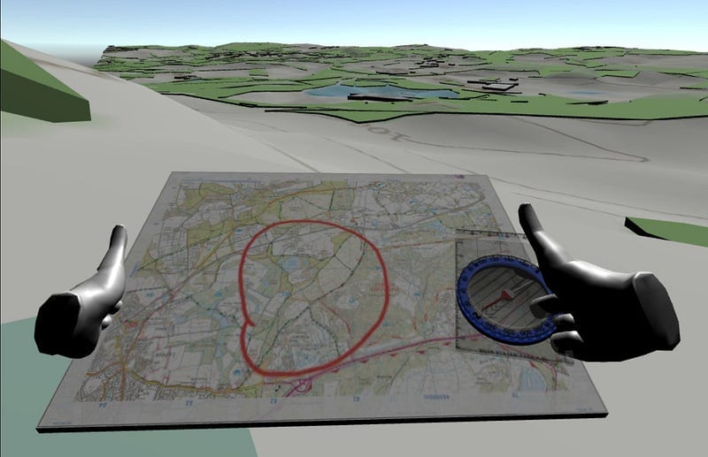
In the UK if you are heading out on a hike then you will be holding an Ordnance Survey Landranger (1:50k) or Explorer (1:25k) map. They do have a map tile API so you could pull this in dynamically for any location in the UK. Though I put this together with a quick static image. And you can see how easy it is to grab a physical map in the world and start to read it.
And then a compass
I was able to create a physical compass that you can pick up, with a needle always pointing north and a dial you can rotate to take a bearing. Adding all the romers and alignment lines so that you can use it against the map.
The VR interaction is not yet perfect, with hands in weird places and not using the other hand to grip and rotate the dial. But as a quick demo, it demonstrates the potential of how you can use the compass just like in real life.
Then to combine it all in the "real" world
Being able to use authentic maps makes the lesson far more powerful. You could train on a real-world location in the classroom then head out into the same place in the wild later. However, if we want to be able to launch a lesson anywhere, then we need to be able to generate that world on the fly from that same real mapping data.
Using open-source data and consumer tools, I was able to create a low-fi human-scale version of anywhere in the world. For these examples in the UK, I used raw data from OS Open Zoomstack data released under the Open Government License, piped through tools provided by Mapbox and their Unity SDK.
The first steps, though a long trail ahead
All of these building blocks of the map, compass and terrain still need polish and perfection. However, this shows all the parts are technically possible and work quite naturally. Though there is a lot more work to build out a full VR navigation training tool beyond these components, this initial work demonstrates the potential of this technique.